
Project Overview and Goals
The Reserved Channel Basin Loop Project is a partnership between Massport, the City of Boston, South Boston government officials, Boston Harbor Now, and ARUP. The partnership is collaborating to create community-led design concepts for completing a continuous public access Harborwalk around the Reserved Channel in South Boston. Funding for the planning of this important project was secured by Senator Nick Collins and Representative David Biele through the state budget process. As shown in the site map below, the Boston Harborwalk currently exists along the majority of the Reserved Channel, but the stretch indicated in orange represents the gap and project area for this planning process. The project goals are to ensure that community interests and desires are prioritized in the design process for expanding public access along this area of the Harborwalk, and that future amenities and improvements to public spaces along this waterfront respond to local needs.
Site Map
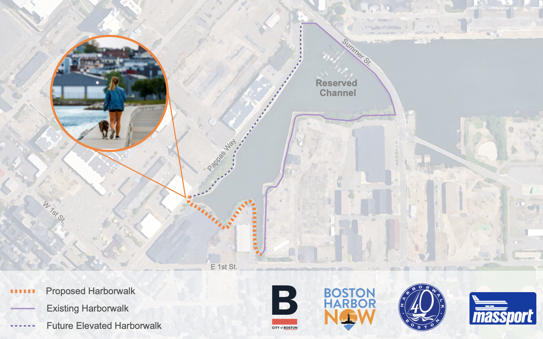
This site map of the Reserved Channel in South Boston showcases the existing Harborwalk segments around the channel, and highlights in orange the connection that this process is planning for.
Existing Conditions
The stretch of Harborwalk considered in this project aims to connect the existing Harborwalk along Pappas Way to the Harborwalk perpendicular to E 1st Street alongside the Eversource substation. Eversource recently completed a different Harborwalk segment nearby, and created First Street Park, which connects the Harborwalk from E 1st Street to the Summer Street Bridge. In addition, a planned Oxford/Pappas redevelopment will also include updates to the Harborwalk along Pappas Way.
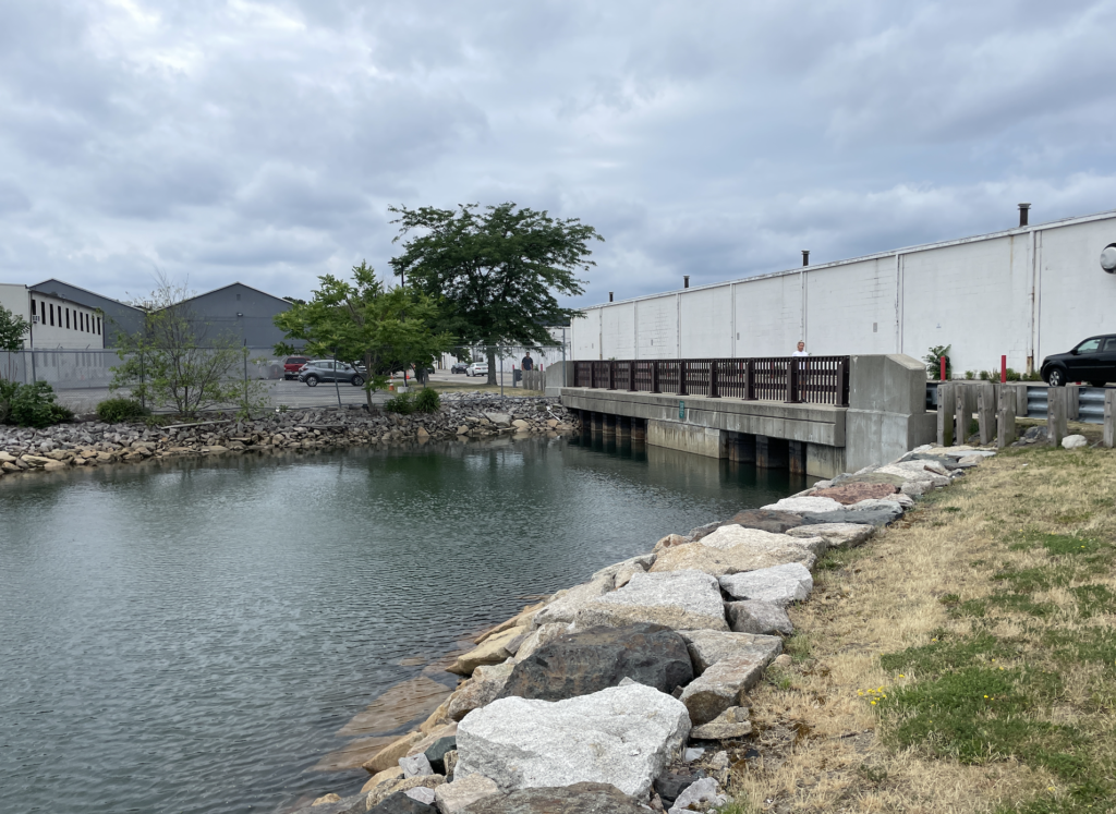
As Harborwalk users approach the project site alongside Pappas Way, the public access trail ends at this bridge. There is no connection between the Pappas Way Harborwalk and the Harborwalk leading to First Street Park.
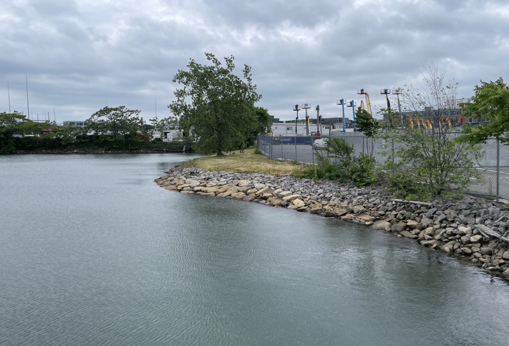
Looking out from the bridge shown in the image above above across the project site, there is a man made rocky shoreline with some vegetation along the area where the planning is focused.
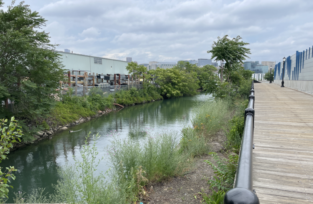
Approaching the project area from the other side, this image shows the narrow channel separating the existing First Street Park Harborwalk on the right side from the project area on the left. The Basin Loop Harborwalk needs to cross over this narrow channel to create a continuous loop.
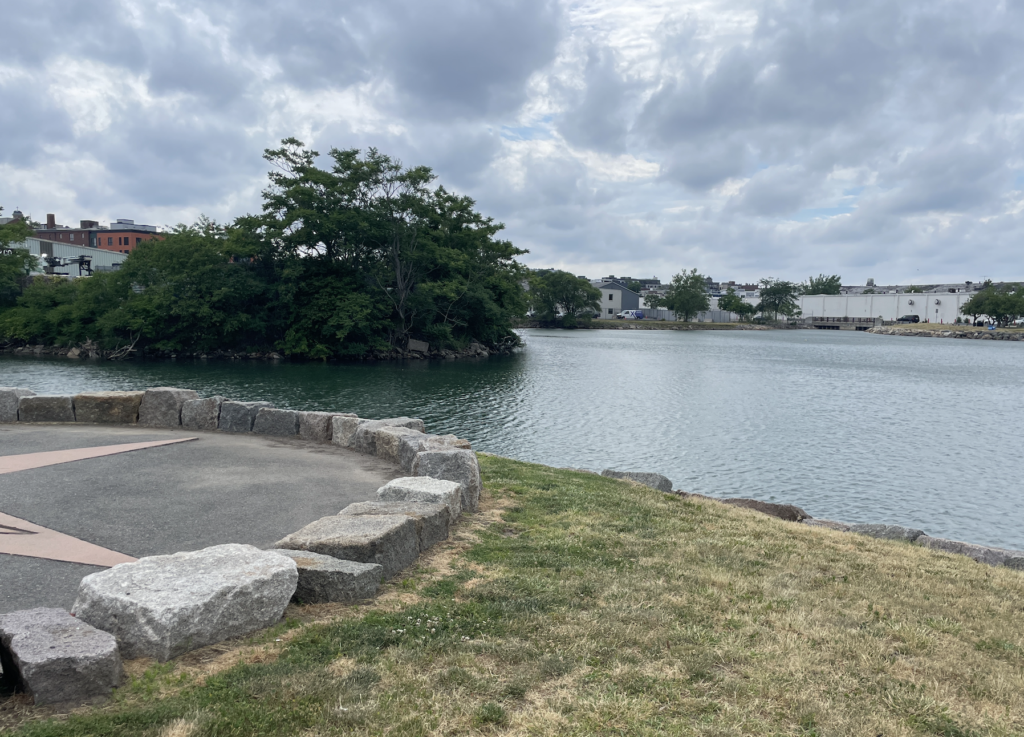
Continuing down the First Street Park Harborwalk segment, this view looks back at the project area. The vegetated corner is being considered as the connection point for a pedestrian bridge that would connect the entire loop.
September 2026 Public Meeting Presentation and Summary
Click this LINK to view the September 24th meeting recording.
Click this LINK to view the September 24th meeting presentation.
The project team hosted a second hybrid community gathering on Thursday, September 24th at the South Boston Public Library Branch and over Zoom to update neighbors, abutting property owners, and local leaders and government officials on design concepts for the future completion of the Harborwalk Basin Loop. The session was led by Boston Harbor Now and Arup, and the team provided an overview of the project objectives and prior feedback, then presented how design concepts were shaped by responses from the May meeting. The meeting had 15 participants in person, and 7 participants joined via Zoom.
The meeting focused on input around public amenities and design options for creating a safe, continuous Harborwalk. The current process is conceptual in nature, with the goal to have design options vetted by the community for future funding or construction opportunities. The objective was to introduce possibilities, share context, and gather public input to inform future planning. Arup presented a range of preliminary concepts, including land-based routes, water-oriented pathways, and a potential pedestrian bridge to improve connectivity and user experience. Agency Landscape and Planning then walked through the evolution of the on land and hybrid design concepts.
To support an inclusive and interactive dialogue, Boston Harbor Now led live polling via Mentimeter (an online interactive engagement tool) and facilitated group discussions to share preferences, priorities, and intended uses of the Harborwalk. The following memo summarizes key themes, poll results, and feedback collected during these discussions to guide the development of conceptual designs for this section of the Harborwalk.
Participants in the September community gathering included neighbors to the project site, people who work around the Reserved Channel, those who use the existing Harborwalk in the area for daily walks and relaxation, abutting property owners, open space advocates, and local and state officials. Participants gave input on proposed spaces they would most enjoy, and offered preferences for overall atmosphere, planting styles, and types of art and interpretation for the Basin Loop connection.
After walking through potential design scenarios for this Harborwalk connection, participants in person and online were asked to vote on which design scenario they prefer. The design concepts and results of that poll are shown below:
Updated Design Concepts
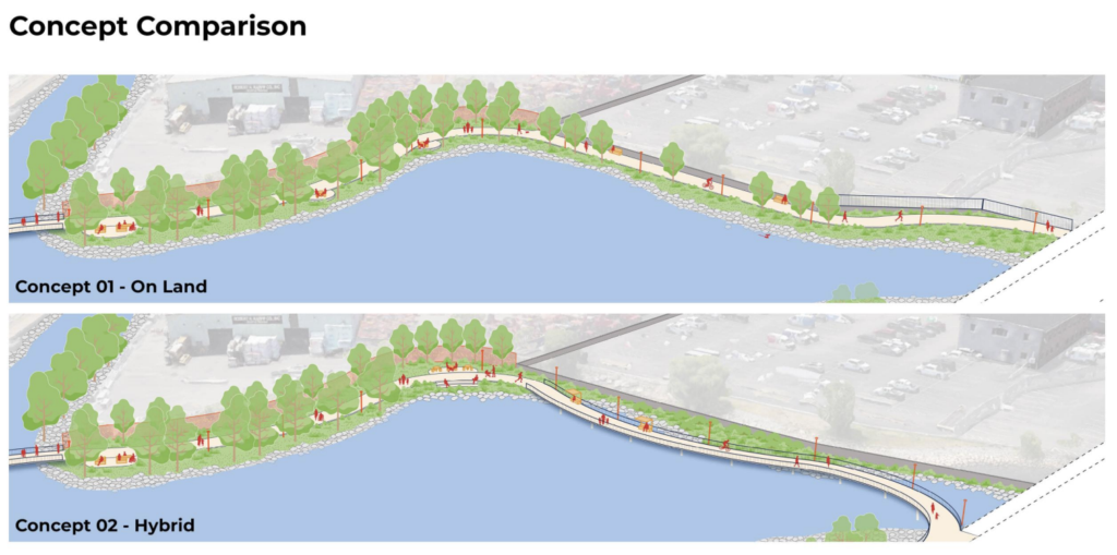
The image above shows the two primary design concepts that were advanced based on community feedback. Both concepts include a pedestrian bridge connection to the First Street Park Harborwalk, and a Harborwalk over land for the first half of the project area. The on land concept continues along the waterfront until it ties into Pappas Way. The hybrid concept features an elevated pathway over water that ties into Pappas Way.
Engagement Results
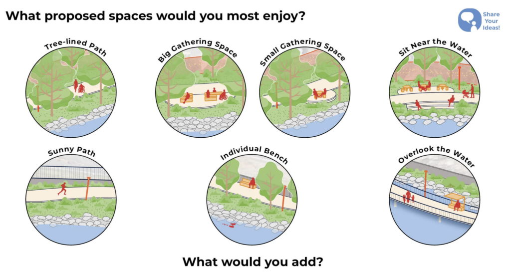
The image above shows different types of spaces and experiences that could be featured along the Basin Loop project site.
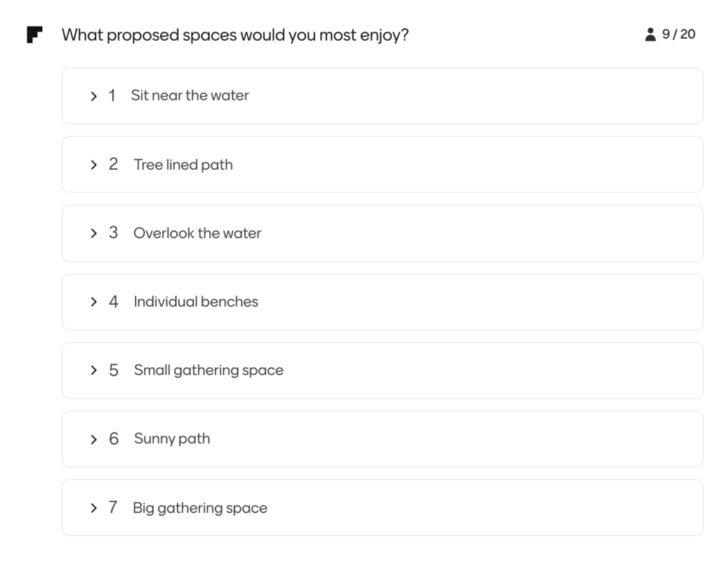
The image above shows the poll results when participants were asked to rank the types of spaces they would most enjoy.
Participants were also asked about how they currently use the Harborwalk, and what design elements/public amenities are needed to support those uses. As in the first meeting, Walking and running were the most common responses, with families, dogs, strollers, and commuting suggesting everyday local use. Participants pointed out the need to ensure the Harborwalk is wide enough to accommodate different types of active transportation, and for design elements to consider how to maximize safety for pedestrians and cyclists.
There were preferences for an atmosphere that honors the maritime industrial history of the area, highlights natural and organic plantings, and interpretive art and signage.
May 2026 Public Meeting Presentation and Summary
Click this LINK to view and download the May 21 Public meeting presentation.
A hybrid community gathering was held on Thursday, May 21, 2026, at the South Boston Public Library Branch and over Zoom to engage neighbors, abutting property owners, and local leaders and government officials in a visioning process for the future completion of the Harborwalk Basin Loop. The session brought together a project team led by Arup and Boston Harbor Now. The team provided an overview of the Harborwalk’s current status, highlighted related and upcoming initiatives by Oxford–Pappas and the U.S. Army Corps of Engineers, and described the specific segment being studied by Massport. The meeting had 30 participants in person, and 15 participants joined via Zoom.
The meeting emphasized that the effort is conceptual in nature, with no funding currently allocated for design or construction. The objective was to introduce possibilities, share context, and gather public input to inform future planning. Boston Harbor Now presented the historical evolution of the area and its alignment with broader Harborwalk goals citywide, while Arup introduced a range of preliminary concepts, including land-based routes, water-oriented pathways, and a potential pedestrian bridge to improve connectivity and user experience.
To support an inclusive and interactive dialogue, attendees participated in live polling via Mentimeter (an online interactive engagement tool) and engaged in breakout group discussions to share preferences, priorities, and intended uses of the Harborwalk. The following memo summarizes key themes, poll results, and feedback collected during these discussions to guide the development of conceptual designs for this section of the Harborwalk.
Participants in the May 21 community gathering included neighbors to the project site, people who work around the Reserved Channel, those who use the existing Harborwalk in the area for daily walks and relaxation, abutting property owners, open space advocates, and local and state officials. Participants highlighted that creating a continuous loop around the Reserved Channel would be “delightful” and “connect communities” in the area, while improving “quality of life”.
After walking through potential design scenarios for this Harborwalk connection, participants in person and online were asked to vote on which design scenario they prefer. The design concepts and results of that poll are shown below:
Initial Design Concepts
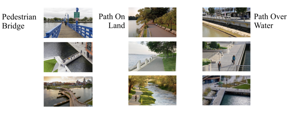
The images above were presented to public meeting participants to showcase the three main design concepts the project team is considering for the Basin Loop.
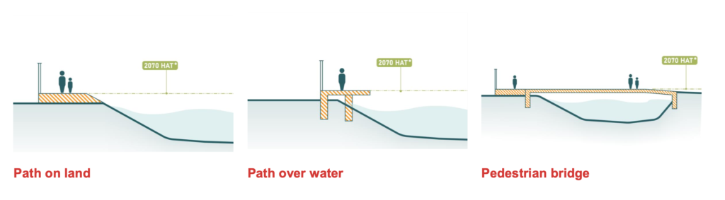
These cross-section images display the differences between the three guiding design concepts. The dotted line with the green label is the Highest Astronomical Tide for 2070, or the highest water level that can be predicted to occur under average weather conditions.
Engagement Results
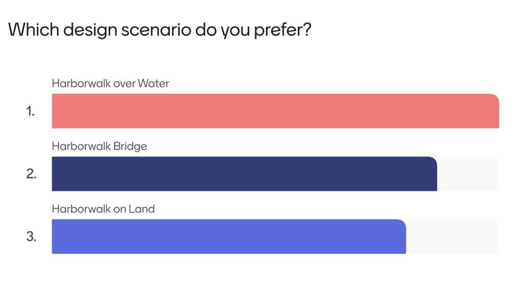
Results from a poll of the May public meeting participants when asked which design scenario they preferred.
Participants were also asked about how they currently use the Harborwalk, and what design elements/public amenities are needed to support those uses. Current uses included:
- Daily walking with family and friends
- Meeting with neighbors and community gathering space
- Frequently used as a place to walk dogs
- Biking access
- Sitting and enjoying the view
- A place to rest
- Fishing
To support these uses, community members advocated for the following amenities:
- More vegetation, native plants, and irrigation
- Water fountains with a bowl for dogs
- Restrooms
- Shade structures
- Seating and picnic areas
- Wayfinding and historical interpretive signage
- Water safety rings
- Garbage bins
- Dark sky lighting and pervious surfaces
Participants also placed colored stickers on maps of the site to indicate how multiple design concepts could be combined on this project site to create a continuous Basin Loop (Pink = Harborwalk over water, Green = Harborwalk as pedestrian bridge, Orange = Harborwalk over land).
Click this link to view the site maps created by participants:
Frequently Asked Questions
What are the next steps for this project?
We will come back to the community with updated designs based on the first round of feedback, and have a public meeting to reach preferred alternatives.
Who can I contact to learn more?
Jason Rundle, Senior Harborwalk Manager, Boston Harbor Now, jrundle@bostonharbornow.org
What is the timeline for this project?
We hope to complete this initial phase of concept design and permitting consultation during 2026, the construction timeline will depend on the funding sources for the project.
Will this project be climate resilient?
This Harborwalk connection is proposed to be elevated above 2070 tidal flood elevations such that Harborwalk access is not impacted by “sunny-day” tidal flooding. As the site is not located on a major flood pathway impacting inland neighborhoods, the proposed Harborwalk connection is not intended to address major flood pathways from extreme storm surge events.
How much will this project cost?
Costs will be estimated in ongoing design processes.