Jenn Kaplan was a summer 2018 fellow at Boston Harbor Now through the Harvard Graduate School of Design’s Community Service Fellowship Program. She researched climate resilient design guidelines and their applicability to Boston. She is now completing her final year in the Masters in Urban Planning program.
In 2012 we watched our neighbors in New York and New Jersey fight against the devastating effects of Superstorm Sandy. Thousands of lives and homes were destroyed across the Atlantic seaboard and some called the near-miss of Boston lucky. But Ellen Douglas, associate professor of hydrology at the University of Massachusetts Boston, said it was a “wake-up call.” The City of Boston is entering an important era where it must adapt to the challenges of climate change at an urban scale.
In many ways, we have already started the process. The City updated its climate action program in 2014, and in 2016 Climate Ready Boston analyzed the vulnerabilities from climate change and laid out an ambitious long-term plan to addresses these challenges. Climate Ready Boston established a foundation for the City to propose neighborhood-specific strategies and update zoning to ensure consistent resilient standards across neighborhood boundaries. In 2018, the City and the Boston Planning & Development Agency embarked on next steps: a Flood Resiliency Overlay Zoning District and supporting Climate Resilient Design Guidelines.
The design guidelines will enhance the character and climate resilience of our waterfront neighborhoods. When considering climate resilient design in an urban setting, it is important to examine how the building weaves into the overall fabric of the neighborhood. Elevating buildings can protect properties from flooding during severe storms, but this can create blank street wall conditions, making it hard for people to visually connect with their surroundings. Noted urban designer Jan Gehl writes that the architecture of cities can be best experienced when “buildings are close together and the combination of detail, faces, and activities contribute to the rich and intense sensory experience.” So what can we learn from existing studies and regulations and other cities to seamlessly integrate resiliency into buildings in a way that contributes to an attractive and multifunctional public realm?
Find ground-floor uses that are floodable for buildings where elevating or floodproofing the ground floor is not feasible.
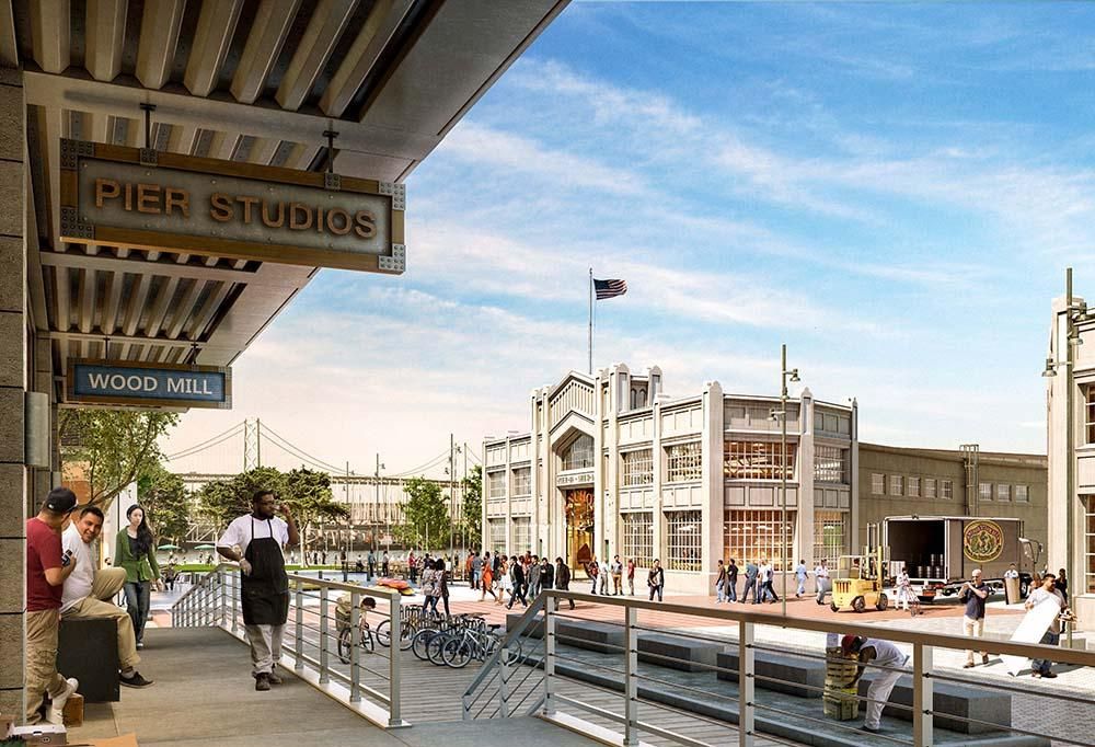
It is important to create an inventory of ground-floor uses that are “floodable” but not detrimental to the street-level experience. The Department of City Planning in New York encourages residents to consider converting residential use to community facility use to activate the ground floor while providing a “sense of security and comfort for pedestrians.” In San Francisco, some mixed-use developments are already starting to tackle this issue by incorporating light industrial use on the ground floor alongside elevated sidewalks.

A mixed-use building with a floodable ground floor with light industrial use in the Mission Rock development in San Francisco, CA (Source: Bisnow)
Consider architectural design solutions that engage and integrate the building with public space, avoiding blank street wall conditions.
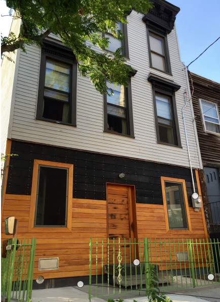
There are several architectural solutions that can be incorporated into buildings and surrounding sites that start to eliminate any boundaries that might exist between individual properties and the streetscape. A well-articulated facade can create a dynamic space, which is important when a building is directly adjacent to a sidewalk. Varying materials and increasing transparency, when possible, can also keep a space lively and exciting to walk through.

An elevated home in the Redhook section of Brooklyn that has varying materials and mechanical equipment above the 100-year flood level (Source: FEMA)
Consider building access that addresses both the scale and design of the surrounding community.
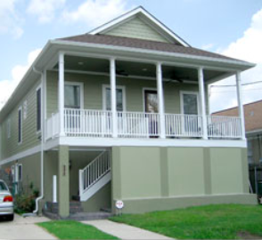
Modifying buildings and streetscapes also involve adding, removing, or re-configuring access points. When considering these new access points, it is important that they are appropriate in scale and integrated into the surrounding site design. This can be challenging given that elevated buildings or sidewalks require longer stairs, ramps, and potentially lifts that are all ADA compliant. It can also be challenging in the Boston area, where property lines are constrained. Property owners could consider maintaining two different entrances: one above the height of the lowest habitable floor when elevated and one at grade through a recessed entrance. They could also move an entrance staircase from above the sidewalk to underneath or adjacent to the building if there is space available.

An elevated home with a recessed staircase and second-story porch in the Broadmoor neighborhood of New Orleans (Source: University of New Orleans)
Consider streetscape design solutions for elevated buildings.
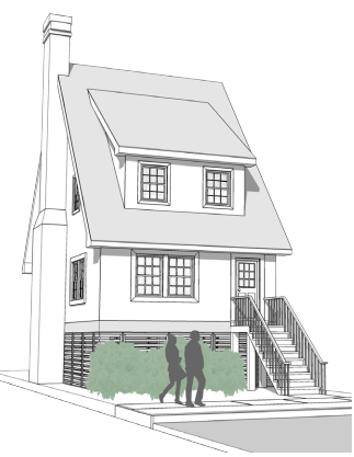
There are several streetscape-specific modifications that can be explored as options. The City of Boston’s Complete Street Design Guidelines indicate that the preferred total width of sidewalk cross sections in residential neighborhoods and industrial streets is 11 feet. Some effective modifications for flood-resilient street design may include building parallel pedestrian zones (one elevated, one at grade) or staggering flow-through planters and bioswales along the pedestrian zone. When possible the City could also consider using low-voltage LED lighting to give elevated landscaping or architecture dramatic lighting.

Planters and bioswales can be planted in pedestrian zones next to elevated homes to support a vibrant streetscape (Source: Department of City Planning, City of New York)
Finally, when considering any of these design strategies to floodproof buildings and activate the public realm in Boston, it is important they are developed alongside regulations at the municipal, state, and federal level. Some of these regulations can lead to challenges for property owners looking to retrofit their homes, such as balancing applicability with cost or finding appropriate floodproofing strategies for site-constrained properties. However, if these design guidelines are developed with property owners, developers, and design teams working together, steps could be taken to concurrently address regulation challenges and design. Strong collaboration between all parties will lead to a resilient city ready to face future challenges that may come our way.
- https://www.bostonglobe.com/metro/2012/11/01/boston-could-vulnerable-more-severe-stormscity-urged-prepare-for-severe-storms-floods/AZHfnGCByUCW2RLFkTMz5I/story.html
- Gehl, Jan. Cities for People. 2nd ed. Island Press, 2010.
- Department of City Planning, City of New York. “Coastal Climate Resilience: Retrofitting Buildings for Flood Risk.” NYC Planning. October 2014. Accessed August 23, 2018.
https://www1.nyc.gov/site/planning/plans/retrofitting-buildings/retrofitting-buildings.page.
- Littman, Julie. “As Sea Level Rises, Architects And Developers Adapt And Innovate.” Bisnow. July 2018. Accessed August 23, 2018. https://www.bisnow.com/san-francisco/news/sustainability/as-sea-level-rises-bay-area-architects-and-developers-adapt-and-innovate-90520.
- Department of City Planning, City of New York. “Designing for Flood Risk.”
- Department of City Planning, City of New York. “Designing for Flood Risk.”
- City of Hoboken. “Resilient Building Design Guidelines.”
- Department of City Planning, City of New York. “Coastal Climate Resilience: Retrofitting Buildings for Flood Risk.”
- Boston Transportation Department “Preferred and Minimum Widths for Sidewalk Zones.” Accessed August 23, 2018. http://bostoncompletestreets.org/pdf/2013/Sidewalks_Chart.pdf
- City of Hoboken. “Resilient Building Design Guidelines.”

Comments